


Lake Tanganyika is the world’s longest (660km), deepest in Africa and second-deepest in the world (more than 1436m) and second-largest (by volume) freshwater lake. At somewhere between nine and 13 million years old, it’s also one of the oldest. Thanks to its age and ecological isolation it’s home to an exceptional number of endemic fish, including 98% of the 250-plus species of cichlids. Cichlids are popular aquarium fish due to their bright colours, and they make Tanganyika an outstanding snorkelling and diving destination.
Comparatively narrow, varying in width from 10 to 45 miles (16 to 72 km), it covers about 12,700 square miles (32,900 square km) and forms the boundary between Tanzania and Congo (Kinshasa). It occupies the southern end of the Western Rift Valley, and for most of its length the land rises steeply from its shores. Its waters tend to be brackish. Though fed by a number of rivers, the lake is not the centre of an extensive drainage area. The largest rivers discharging into the lake are the Malagarasi, the Ruzizi, and the Kalambo, which has one of the highest waterfalls in the world (704 feet [215 metres]). Its outlet is the Lukuga River, which flows into the Lualaba River.
Lake Tanganyika is situated on the line dividing the floral regions of eastern and western Africa, and oil palms, which are characteristic of the flora of western Africa, grow along the lake’s shores. Rice and subsistence crops are grown along the shores, and fishing is of some significance. Hippopotamuses and crocodiles abound, and the bird life is varied.
Many of the numerous peoples (predominantly Bantu-speaking) living on the lake’s eastern borders trace their origins to areas in the Congo River basin. The lake was first visited by Europeans in 1858, when the British explorers Sir Richard Burton and John Hanning Speke reached Ujiji, on the lake’s eastern shore, in their quest for the source of the Nile River. In 1871 Henry (later Sir Henry) Morton Stanley “found” David Livingstone at Ujiji. Important ports situated along Lake Tanganyika are Bujumbura (Burundi), Kalemi (Congo), and Ujiji and Kigoma (Tanzania).

Lake Victoria
With a surface area of 68,800 sq km (26,600 sq mi), Lake Victoria is Africa’s largest lake. In addition, it's the largest tropical lake in the world, and the planet's second largest freshwater lake. Only North America's Lake Superior is larger.
An irregular quadrilateral in shape, its shores, save on the west, are deeply indented. Its greatest length from north to south is 210 miles (337 km), its greatest breadth 150 miles (240 km). Its coastline exceeds 2,000 miles (3,220 km). Its waters fill a shallow depression in the centre of the great plateau that stretches between the Western and Eastern Rift Valleys. The lake’s surface is 3,720 feet (1,134 metres) above sea level, and its greatest ascertained depth is 270 feet (82 metres). Many archipelagos are contained within the lake, as are numerous reefs, often just below the surface of the clear waters. Lake Victoria has more than 200 species of fish, of which the Tilapia is the most economically important. The lake’s basin area covers 92,240 square miles (238,900 square km).
The lake’s shores vary in aspect. The lake’s southwestern coast is backed by precipices 300 feet (90 metres) high, which give way on the western coast to papyrus and ambatch swamps marking the delta of the Kagera River. The lake’s deeply indented northern coast is flat and bare. A narrow channel leads into the Kavirondo Gulf, which has an average width of 16 miles (25 km) and extends for 40 miles (64 km) eastward to Kisumu, Kenya. The Ugandan cities of Kampala and Entebbe lie along or near the northern coast. At the lake’s southeastern corner is Speke Gulf, and at the southwestern corner Emin Pasha Gulf. Of the numerous islands in the lake, Ukerewe, north of Speke Gulf, is the largest, with wooded hills rising 650 feet (200 metres) above the lake. It is densely populated. At the lake’s northwestern corner are the 62 islands of the Sese archipelago, some of them of striking beauty.
The Kagera River, the largest and most important of the lake affluents, enters the western side of Lake Victoria just north of latitude 1° S. The only other river of note entering from the west is the Katonga, north of Kagera. The lake’s only outlet is the Victoria Nile, which exits from the northern coast.
The search by Europeans for the source of the Nile led to the sighting of the lake by the British explorer John Hanning Speke in 1858. Formerly known to the Arabs as Ukerewe, the lake was named by Speke in honour of Queen Victoria of England. A detailed survey of the lake was made by Sir William Garstin in 1901. Plans for gradually raising the level of the lake’s waters were completed in 1954 with the construction of the Owen Falls Dam (now the Nalubaale Dam) on the Victoria Nile at Jinja, Uganda. The dam provides hydroelectric power on a large scale and made the lake a vast reservoir. A second dam, Kiira, was later constructed 0.6 mile (1 km) from Nalubaale. It was completed in 1999 and began producing hydroelectric power the next year.
The Lake Victoria region is one of the most densely populated in Africa; within 50 miles (80 km) of its shores live several million people, nearly all Bantu-speaking. There are local steamer services around the lake.

Lake Nyasa
Lake Nyasa, also called Lake Malawi, lake, southernmost and third largest of the East African Rift Valley lakes of East Africa, lying in a deep trough mainly within Malawi.
Lake Nyasa (Nyasa means “lake”) is located at the south-west of Tanzania, The lake lies in three countries’ territory; Tanzania and Malawi. However, it is bordered by three countries, Tanzania , Malawi and Mozambique. It is the third largest in Africa (after Lake Victoria and lake Tanganyika) with 550 kilometers length and 75 kilometers width, covering an area of more than 11,400 square kilometers. In some parts, the lake is as deep as 700 meters.
The Lake lies in the sided walls of mountain ranges: the forested Livingston Mountains and Nyika Plateau, which provide the magnificent view of the lake from far and the landscape for hikers and backpackers.
Lake Nyasa is also among the Great Rift Valley’s lakes, which shares some of the characteristics with lake Tanganyika. The lake has a distinctive characteristic: 14 rivers pouring their waters into the lake, and only one river which flows out to the sea, River Shire.
The Lake also has a lot of names such as “Lake of stars” which is provided by the lovers who trip their and discover it one of the dreamy and romantic destination in Eastern Africa. It is situated between Malawi, Mozambique as well as Tanzania. It has so many things to offer such as numerous opportunities for water sports as well as diving. The lake is enormously rich with diverse fish species and is one of the most appealing lakes that offer unforgettable underwater views!
Some parts of the lake offer nice beaches and places to swim. Matema, in the northern part of the lake is considered to be the best beach for people who like to relax swim along the lake shore. In contrast to other lakes the water of lake Nyasa is bilharzias free. There are also caves and interesting waterfalls to see.
Other activities include local canoeing ride down the river, hiking on surrounding mountains.
Though Lake Nyasa does not receive many tourists, the lake is magnificently attractive and is rich in crocodiles and hippopotamus. For Fish lovers, Lake Nyasa is biologically the most diverse lake, containing approximately 30% of world’s cichlid species (colorful fish which are easily seen in the lake’s clear water)
Volume 7,775.00 km3, Surface Area 29,500.00 km2, Depth Mean depth: 264.0m Maximum depth: 706.0m
Lake Ngozi
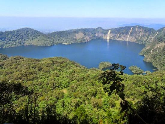
Lake Ngozi, a thrilling crater lake in Southern Highlands of Tanzania
Expand map
Standing as the second largest Crater Lake in Africa, Ngosi Lake is the leading tourist attraction in Rungwe district pulling hundreds of visitors each year.
The lake is located about 38 kilometers south of Mbeya city, near the sprawling Tukuyu Township. It is located on Ngosi peak on the Uporoto Mountains which makes part of Eastern Arc ranges.
It is located at an uplift of 2,600 meters above sea level in a thick, natural forest of the Uporoto nature reserve, covering some 9,332 hectares of land. It has a length of 2.5 kilometers and width of 1.5 kilometers and 75 meters deep.
To reach the lake, one has to drive and stop at the edge of the Uporoto Forest Reserve at the foothills of the Uporoto range. It takes up to two hours walking from the foothill to the ridge where the lake lies at 200 meters below.
It is an exciting adventure to trek or walk through the dense montane forest to the crater rim. Monkeys and many bird species can be seen in the forest which is also home to an endemic species of chameleon and montane, wild banana trees.
Walking and climbing the Uporoto range is organized by special guides familiar to the route which is made up of cascades, horrific gorges and valleys where someone could fall with no option of rescue. It is risky to fall into the gorges if one trek without care, and, if one falls into one of numerous gorges on the way to the lake, it will be the end of his or her life.
Despite those risks, it is automatically safe to trek the Uporotos and view magnificent Lake Ngozi which is a sight of outstanding natural beauty and a superb hiking hotspot.
It is a green shimmering lake walled by the collapsed caldera of the extinct Ngozi Volcano. The peak is the highest point of the Uporoto Ridge Forest Reserve. The forest has an endemic three horned chameleon (Chameleon fuelleborni).
This stunning caldera lake dates from some time in the Neocene period. The water is slightly brackish, contains some fish, and is up to 75 m deep. The lake has spiritual significance for the local inhabitants.
A caldera is a roughly circular depression formed by the collapse of a magma chamber roof onto its magma body beneath. It is a large rounded depression resulting from the destruction of a volcano in a violent eruption.
The mountain and the lake are counted to an age of one million years, and remains an old volcano that has now collapsed to form a wide caldera filled with a shining alkaline ‘soda’ waters.
The waters of the lake are said to have magical medicinal powers. Ngozi means ‘The Big One’; in vernacular Kinyakyusa dialect.
Climbers looking to view this scenic lake are well rewarded with excellent views from the top of the sharp crater rim, from where the lake gleams below with an overwhelming tranquil air, and beyond the land are pocked with the points of smaller volcanic peaks.
Walking to the rim leads through upland grasslands and tropical forests where families of Colobus monkeys chatter and play, and a miasma of birds take refuge.
The path leads into the forest for about 2.5km and then begins the climb to the crater top. Just before the top, the path branches in two; the right hand path leads swiftly to the peak, and the left leads down to the water’s edge

Lake Chala is a unique caldera lake, and is thought to be the deepest inland body of water in Africa. This lake is fed by underground springs from Mt. Kilimanjaro.
The lake has a great diversity of life. From lush lake shore forest to stunning volcanic savannah; from river beds marvelously carved through ancient rock, to thick bush or open ‘mbuga’. Walking at Lake Chala is a magical experience that will put you back in touch with nature.
The lake is fed by groundwater flows, which come from Mount Kilimanjaro, fed and drained underground with a rate of about 10 million m³ / year. Depending on the time of year, it ranges in colour from deep blue to turquoise and green, it is surrounded by a 100 metres high crater rim.
Chala has a huge variety of amazing trees, grasses and plants; some are unique to the area. According to the time of year there are hundreds of species of butterflies and birds, including spectacular birds of prey. The African Fish Eagle, with its haunting techniques, Verreaux’s Eagle, Augur Buzzards and many other species of birds can be seen around the crater walls. Wild mammals do vary including Blue Monkeys, Colobus Monkeys, baboons, dik-dik, kudu and elephant. Chala is an untouched part of a truly ancient land and a must visit place.
Activities at this lake: walking safaris, canoeing, swimming and fishing.

Lake Manyara National Park
Located beneath the cliffs of the Manyara Escarpment, on the edge of the Rift Valley, Lake Manyara National Park offers varied ecosystems, incredible bird life, and breathtaking views.
Located on the way to Ngorongoro Crater and the Serengeti, Lake Manyara National Park is worth a stop in its own right. Its ground water forests, bush plains, baobab strewn cliffs, and algae-streaked hot springs offer incredible ecological variety in a small area, rich in wildlife and incredible numbers of birds.
The alkaline soda of Lake Manyara is home to an incredible array of bird life that thrives on its brackish waters. Pink flamingo stoop and graze by the thousands colourful specks against the grey minerals of the lake shore. Yellow-billed storks swoop and corkscrew on thermal winds rising up from the escarpment, and herons flap their wings against the sun-drenched sky. Even reluctant bird-watchers will find something to watch and marvel at within the national park.
Lake Manyara’s famous tree-climbing lions are another reason to pay a visit to this park. The only kind of their species in the world, they make the ancient mahogany and elegant acacias their home during the rainy season, and are a well-known but rather rare feature of the northern park. In addition to the lions, the national park is also home to the largest concentration of baboons anywhere in the world — a fact that accounts for interesting game viewing of large families of the primates.
Stretching for 50km along the base of the rusty-gold 600-metre high Rift Valley escarpment, Lake Manyara is a scenic gem, with a setting extolled by Ernest Hemingway as “the loveliest I had seen in Africa”.
The compact game-viewing circuit through Manyara offers a virtual microcosm of the Tanzanian safari experience.
From the entrance gate, the road winds through an expanse of lush jungle-like groundwater forest where hundred-strong baboon troops lounge nonchalantly along the roadside; the blue monkeys scamper nimbly between the ancient mahogany trees; dainty bushbuck tread warily through the shadows, and the outsized forest hornbills honk cacophonously in the high canopy.
In contrast with the intimacy of the forest, is the grassy floodplain and its expansive views eastward, across the alkaline lake, to the jagged blue volcanic peaks that rise from the endless Maasai Steppes. Large buffalo, wildebeest and zebra herds congregate on these grassy plains, and so do the giraffes – some so dark in coloration that they appear to be black from a distance.
Inland of the floodplain, a narrow belt of acacia woodland is the favoured haunt of Manyara’s legendary tree-climbing lions and impressively tusked elephants. Squadrons of banded mongoose dart between the acacias, whereas the diminutive Kirk’s dik-dik forages in their shade. Pairs of klipspringer are often seen silhouetted on the rocks above a field of searing hot springs that steams and bubbles adjacent to the lakeshore in the far south of the park.
Manyara provides the perfect introduction to Tanzania’s birdlife. More than 400 species have been recorded, and even a first-time visitor to Africa might reasonably expect to observe 100 of these in one day. Highlights include thousands of pink-hued flamingos on their perpetual migration, as well as other large water birds such as pelicans, cormorants and storks.
About Lake Manyara National Park
Size: 330 sq km (127 sq miles), of which up to 200 sq km (77 sq miles) is the lake when water levels are high.
Location: Northern Tanzania. The entrance gate lies 1.5 hours (126km/80 miles) west of Arusha along a newly surfaced road, close to the ethnically diverse market town of Mto wa Mbu.

Lake Natron
A soda lake at the base of the active Ol Donyo Lengai volcano, the area around Lake Natron is often described as having a desolate and almost lunar beauty. Lake Natron is found in the northern part of Tanzania. Nearest towns to Lake Natron are Arusha in Tanzania and Magadi in Kenya. It is the most important breeding site for Lesser Flamingos in the world.
East Africa has 1.5-2.5 million Lesser Flamingos, representing three-quarters of the world population and most of them are hatched at Lake Natron. Food is plentiful, nesting sites abound – and above all, the lake is isolated and undisturbed. The lake and its ecosystem provides a source of livelihoods to the local communities.
High levels of evaporation have left behind natron (sodium carbonate decahydrate) and trona (sodium sesquicarbonate dihydrate). The alkalinity of the lake can reach a pH of greater than 12. The surrounding bedrock is composed of alkaline, sodium-dominated trachyte lavas that were laid down during the Pleistocene period. The lavas have significant amounts of carbonate but very low calcium and magnesium levels. This has allowed the lake to concentrate into a caustic alkaline brine
Walks around the lake and to the streams and waterfalls along the nearby escarpment make for a fantastic adventure off the beaten track.
There are a number of campgrounds near the lake, which is also the base for climbing Ol Doinyo Lengai.


No comments:
Post a Comment